Leningrad Region: pages of history
Leningrad Region: pages of history

The selection presents studies, sketches, documents, photo and video materials, that reveal the geographical, socio-economic, political and other aspects of the history of the Leningrad Region in the period of the 18th - early 20th centuries. There is also the current Charter of the Leningrad Region.

Map of the St. Petersburg Gubernia, divided into counties and city plans: Yamburg, Luga, Oranienbaum, Novaya Ladoga, Tsarskoye Selo, Shlisselburg and Gdov
Russia. Ministry of the Interior. Technical and Construction Committee. Map of the St. Petersburg province, divided into counties and city plans: Yamburg, Luga, Oranienbaum, Novaya Ladoga, Tsarskoye Selo, Shlisselburg and Gdov. 1778 - 1839.
1778
Федеральное казенное учреждение "Российский государственный исторический архив"

Map of the part of the Luga district of St. Petersburg province
Russia. Ministry of the Interior. Technical and Construction Committee. Map of the part of the Luga district of the St. Petersburg province. [1782-1917].
1782
Федеральное казенное учреждение "Российский государственный исторический архив"
Plans for the parts of the town of Luga in the St. Petersburg province with the designation and description of existing buildings and the indication of places for buildings intended for construction
Plans for parts of the town of Luga in the St. Petersburg province with the designation and description of existing buildings and the indication of places for buildings intended for construction. 1839-1841.
1839
Федеральное казенное учреждение "Российский государственный исторический архив"

Plan Shlisselburgsky district of the St. Petersburg province
Plan Shlisselburgsky district of the St. Petersburg province. 1747.
1747
Федеральное казенное учреждение "Российский государственный исторический архив"

View of the church of St. George. Art. Ladoga. yorussian empire
Prokudin-Gorskii, Sergei Mikhailovich (1863-1944). Vid na tserkov 'Sv. Georgiia. St. Ladoga. [Rossiiskaia imperiia]. [1909].
1909
Library of Congress

Wall painting in the church of St. George. yuStaraya Ladoga, the Russian empire
Prokudin-Gorskii, Sergei Mikhailovich (1863-1944).
Stiennaia zhivopis' v tserkvi Sv. Georgiia. [Staraia Ladoga, Rossiiskaia imperiia].
[1909].
[1909].
1909
Library of Congress

View of Novaya Ladoga. yorussian empire
Prokudin-Gorskii, Sergei Mikhailovich (1863-1944). Vid na Novuiu Ladogu. [Rossiiskaia imperiia]. [1909].
1909
Library of Congress

junikolskaya church in Lavrovo (?), Shlisselburg county of St. Petersburg province
Prokudin-Gorskii, Sergei Mikhailovich (1863-1944). [Nikol'skaia tserkov'v Lavrovo (?), Shlissel'burgskogo uezda Sankt-Peterburgskoi gubernii]. [1909].
1909
Library of Congress
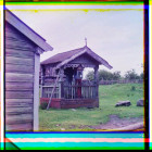
Chapel and the cross of the time of Peter I in the village of Sumskoye. yorussian empire
Prokudin-Gorskii, Sergei Mikhailovich (1863-1944). Chasovnia i krest vremeni Petra I v derevnie Sumskoe. [Rossiiskaia imperiia]. [1909].
1909
Library of Congress

Sobor vo imia Sv. Ap. Petra i Pavla v. G. Lod. pole
Prokudin-Gorskii, Sergei Mikhailovich (1863-1944). Sobor vo imia Sv. Ap. Petra i Pavla v. G. Lod. pole. [1915].
1915
Library of Congress