| Description |
|
| |
|
|
|
|
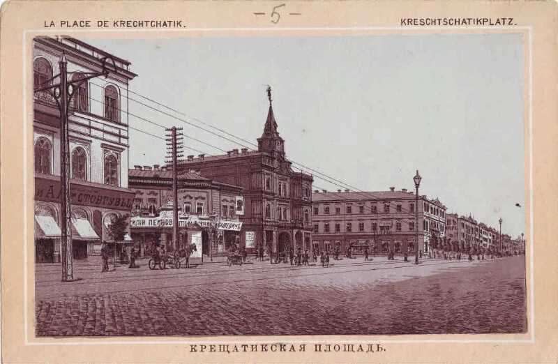
Khreshchatyk Square [Izomaterial] = La place de Krechtchatik = Kreschtschatikplatz: species photography. - [beg. XX century.]. - Phototype; 12x18; 9.7 × 15.9. - (Kiiv - Souvenir de Kieff). - The image is horizontal. - General view of Khreshchatytska Square. In the center is the City Duma building
.
|
|
|
|
1. Territory of Russia (collection). 2. Kiev - early. 20 cent. - Species photo. 3. Independence Square (Kiev, city) - History - early. 20 cent. -- Photo. 4. Photos are documentary. |
|
1. area. 2. city. 3. phototype |
ББК 85.163 (4Укр-2Киев)
ББК 63.3 (28-8Кие-2Киев) 53я61
|
|---|
|
In the late XVIII - early XIX century. on the site of the future square was a wasteland with the remains of defensive shafts emerging on it. The area as such was formed in the 1830s, when the remains of these ramparts were demolished, and then it was called Khreshchatytska. Here the first wooden ones appeared, and in the 1850s. - stone buildings. Until 1871 there was a market on the square, there were circus performances, parties. Since 1876, after the construction of the City Duma building (architect A. Schiele), which was not preserved, the area was called the Dumskaya. The area suffered greatly during the Nazi occupation. In 1976-1977, 2000-2001 - was reconstructed. Now it's Maydan Nezalezhnosti. |
Source of electronic copy: National Parliamentary Library of Ukraine
Location of original material: National Parliamentary Library of Ukraine
|
|