| Description |
|
| |
THE USSR. Map. 1: 2,500,000. |
|
|
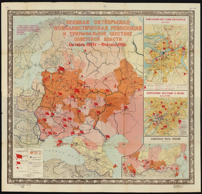
The Great October Socialist Revolution and the triumphal march of Soviet power [Maps]: October 1917 - February 1918 / comp. Scientific ed. the cartographer. part of the GUM in 1947 and corrected. in 1954; otv. Ed. Martov K. B. - 1: 2 500 000, 25 km in 1 cm; the projection is conical conformal. -Moscow: Main Directorate of Geodesy and Cartography of the USSR Ministry of Internal Affairs, 1954. -1 k. (4 leaves in the general frame): color, 3 ext. maps, text, ill. ; 75х81 cm. -
Cartographic grid in 5 °.
Longitude from Greenwich.
Relief by tush welding.
В-351.
Усл. signs: the boundaries of the Russian Empire in 1914, the boundaries of the provinces of the Russian Empire in 1914, the front line by October 1917, the time of the transfer of power to the Soviets by the provinces and industrial regions, settlements in which the Bolsheviks had a majority in the Soviets on the eve of the October Uprising , the victory of the armed insurrection in Petrograd and Moscow, the establishment of Soviet power in other cities, the date of the establishment of Soviet power (according to the old style), etc.
Quote from Lenin's speech, October 25, 1917
30 000 copies
Add. maps: Armed uprising in Petrograd 25.X.1917 1:25 000; Armed uprising in Moscow 25.X - 2.XI. 1917 1:30 000; The Asian part of Russia. 1:12 500 000.
. |
|
I. Martov, K. B. II. THE USSR. Main Department of Geodesy and Cartography. Scientific and editorial cartographic part.1. 1917: February - October (collection). 2. Power (collection). 3. Russia - History - 1917 - 1918 - Maps. 4. Historical maps. |
BBC 63.3 (2) 611y64
|
|---|
Electronic copy source: PB
Location on the original: ГПИБ. Center for Social and Political History |
|