Plans
Plans

The plan of the capital city of St. Petersburg with the image of the most famous avenues
Plan of the capital city of St. Petersburg with the image of the noblest avenues. St.Petersburg: [Printing House of the Academy of Sciences], 1753.
1753
РГБ

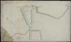
The plan of the part of the Peterhof road from the embankment of the Fontanka River to the Red Kabachka in St. Petersburg province with the indication of the projected bridges and the name of the owners of the plots along the road
Plans and drawings of waterways and highways. Collection.
The plan of the part of the Peterhof road from the embankment of the Fontanka River to the Red Kabachka in the St. Petersburg province with the indication of the projected bridges and the name of the owners of the plots along the road.
The plan of the part of the Peterhof road from the embankment of the Fontanka River to the Red Kabachka in the St. Petersburg province with the indication of the projected bridges and the name of the owners of the plots along the road.
1812
Федеральное казенное учреждение "Российский государственный исторический архив" (РГИА)

Plans, facades of stone bridges along the St. Petersburg road in St. Petersburg province, requiring correction
Plans and drawings of waterways and highways. Collection.
Plans, facades of stone bridges along the Petersburg road in the St. Petersburg province, requiring corrections.
Plans, facades of stone bridges along the Petersburg road in the St. Petersburg province, requiring corrections.
1825
Федеральное казенное учреждение "Российский государственный исторический архив" (РГИА)

St. Petersburg Province. Plan of St. Petersburg. 1828
Russia. Ministry of the Interior. Technical and Construction Committee. St. Petersburg Province. Plan of St. Petersburg. 1828, 1828.
1828
Федеральное казенное учреждение "Российский государственный исторический архив"
The location of bridges on the Fontanka, Pryazhka, Tarakanovka, Catherine Canal rivers in St. Petersburg
Plans and drawings of waterways and highways (collection).
A plan for the location of bridges on the Fontanka, Pryazhka, Tarakanovka, Catherine Canal rivers in St. Petersburg.
A plan for the location of bridges on the Fontanka, Pryazhka, Tarakanovka, Catherine Canal rivers in St. Petersburg.
1795
Федеральное казенное учреждение "Российский государственный исторический архив" (РГИА)

Numbering houses in St. Petersburg, with alphabetical lists of avenues, streets, squares, embankments, bridges, Neva piers, city entrances, cathedral and parish churches, palaces, monuments and house owners
Numbering of houses in St. Petersburg, with alphabetical lists of avenues, streets, squares, embankments, bridges, Neva piers, city entrances, cathedral and parish churches, palaces, monuments and house owners. [St. Petersburg], 1836.
1836
РГБ

City of St. Petersburg with a description of urban buildings, bridges and avenues. Plan
Plans and drawings of waterways and highways (collection).
City of St. Petersburg with a description of urban buildings, bridges and avenues. Plan.
City of St. Petersburg with a description of urban buildings, bridges and avenues. Plan.
1837
Федеральное казенное учреждение "Российский государственный исторический архив" (РГИА)

Guard booth at chain bridges in St. Petersburg
Plans and drawings of waterways and highways (collection).
Guardhouse at chain bridges in St. Petersburg.
Guardhouse at chain bridges in St. Petersburg.
1837
Федеральное казенное учреждение "Российский государственный исторический архив" (РГИА)

The plan of St. Petersburg, divided into parts of the police department, and a detailed index of state and public buildings, churches, palaces, bridges and streets
The plan of St. Petersburg, divided into parts of the police department, is accompanied by a detailed index of state and public buildings, churches, palaces, bridges and streets indicated on the plan. [St. Petersburg]: published by IO Ivanov, 1882.
1882
ЦГПБ им. В.В. Маяковского (Санкт-Петербург)
Мосты (Ск. 39-42)