Far East until 1917
Far East until 1917

Statement of General Unterberger's opinion on the state of affairs in the Far East
Stolypin, Pyotr Arkadevich (1862-1911).
Statement of General Unterberger's opinion on the state of affairs in the Far East.
[19 -].
[19 -].
1910
РГИА

Дело о запросе членов Государственной думы Третьего созыва Председателю Совета министров по поводу выработки общего плана по борьбе с эпидемией чумы на Дальнем Востоке и в Сибири
17-19 января 1911 г.
Федеральное казенное учреждение "Российский государственный исторический архив" (РГИА)

The Case of the request of members of the State Duma of the third convocation of the Chairman of the Council of Ministers on the measures taken to combat the epidemic of plague in the territory of the Chinese Eastern Railway, in the Amur General Government and in Siberia
Duma I, II, III and IV callings.The Case of the request of members of the State Duma of the third convocation of the Chairman of the Council on the measures taken to combat the epidemic of plague of Ministers on the territory of the Chinese Eastern Railway, in the Amur General Government and in Siberia.
1911
Federal state institution "Russian State Historical Archives" (RSHA)

On the formation of an interdepartmental conference on the affairs of the Far East; logs of meetings and materials. Meetings on the issues: improvement of the resettlement business, development of communications and fishing industry, protection of commercial resources, improvement of the conditions of troops in the Amur region, construction of ports, administrative transformation of the Amur, Primorsky and Sakhalin regions, the opening of schools and others.
Council of Ministers (1905-1917).
On the formation of an interdepartmental conference on the affairs of the Far East; logs of meetings and materials. Meetings on issues: improvement of the resettlement business, development of communication lines and fishing industry, protection of commercial resources, improvement of conditions of troops in the Amur region, construction of ports, administrative transformation of the Amur, Primorsky and Sakhalin regions, opening of schools, etc. < / td>
On the formation of an interdepartmental conference on the affairs of the Far East; logs of meetings and materials. Meetings on issues: improvement of the resettlement business, development of communication lines and fishing industry, protection of commercial resources, improvement of conditions of troops in the Amur region, construction of ports, administrative transformation of the Amur, Primorsky and Sakhalin regions, opening of schools, etc. < / td>
1913
Федеральное казенное учреждение "Российский государственный исторический архив" (РГИА)

On the release of funds for the purchase of a plot of land in the city of Khabarovsk to build a building for the Amur Chamber of Control
Russia. Council of Ministers. On the release of funds for the purchase of a plot of land in the city of Khabarovsk to build a building for the Amur Chamber of Control. 1914.
1914
РГИА

The case of installments to the cities of Tyumen Tobolsk Province., Chita, Zabaikalskaya obl. and Romnam Poltava Bay. payment of the shortage of the allowance to the treasury
Russia. Council of Ministers
The case of installments to the cities of Tyumen Tobolsk Province., Chita, Zabaikalskaya obl. and Romnam Poltava Bay. payment of the shortage of the allowance to the treasury due to them. Film of 1917.
1917
ФГУ Российский Гоударственный Исторический Архив

Formation and development of the penitentiary system in the Far East in the second half of the XIX - early XX centuries.
Nikitina, Irina Vyacheslavovna (Candidate of Sciences).
Formation and development of the penitentiary system in the Far East in the second half of the XIX - early XX centuries .. Vladivostok, 2006.
2006

Criminal criminality and search in Transbaikalia during the inter-revolutionary period
Petrov, Artem Sergeevich. Criminal criminality and search in Transbaikalia during the inter-revolutionary period. Vladivostok, 2016.
2016
Pages
- Cartographic materials
Asia.- [17 - -]
Asia.- [17 - -].
The map representing inventions by Russian sailors in the northern part of America with near the lying places of the studied / composed at the imper.Academy of Sciences with the titular adviser Ivan Trusk.- [17 - -]
The map representing inventions by Russian sailors in the northern part of America with near the lying places of the studied / composed at the imper.Academy of Sciences with the titular adviser Ivan Trusk.- [17 - -].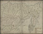
Map of the Yakut region on the lower reaches of the river.Lena from Vitim to the mouth and Kamchatka, comp.P. Skobeltsin, I. Svistunov, D. Baskakov, V. Shetilov
Map of the Yakut region on the lower reaches of the river.Lena from Vitim to the mouth and Kamchatka, comp.P. Skobeltsin, I. Svistunov, D. Baskakov, V. Shetilov.
Landantcart of Eastern Siberia from the prison of Vitim to Kamchatka, comp.P. Skobeltsin, I. Svistunov, D. Baskakov, V. Shetilov
Landantcart of Eastern Siberia from the prison of Vitim to Kamchatka, comp.P. Skobeltsin, I. Svistunov, D. Baskakov, V. Shetilov.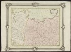
Part of the Mangazesiskago and Yakutskogo county with the mouths of the Yenisei and Lena / Op.I. Truskot;Cutting P. Kholodov;Grid.I. Kuvakin
Part of the Mangazesiskago and Yakutskogo county with the mouths of the Yenisei and Lena / Op.I. Truskot;Cutting P. Kholodov;Grid.I. Kuvakin.1770.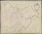
The eastern part of the Yakutsk district / Op.I. Truskot;I. Kuvakin cut out
The eastern part of the Yakutsk district / Op.I. Truskot;I. Kuvakin cut out.1772.
The sea of Baikal with part of the rivers of Lena, Arguni, Selenges and Angara with near the lying counties
The sea of Baikal with part of the rivers of Lena, Arguni, Selenges and Angara with near the lying counties.[St. Petersburg: Geographical Department of the Imperial Academy of Sciences], 1772.
The first manuscript map of Kamchatka, the Aleutian Islands and Alaska, compiled by Major TI Shmalev
The first manuscript map of Kamchatka, the Aleutian Islands and Alaska, compiled by Major TI Shmalev. 1775.
Map of the Chukotsky Nose / communicated from Colonel Pretnener;OSR [RI].L. SERGEEV
Map of the Chukotsky Nose / communicated from Colonel Pretnener;OSR [RI].L. SERGEEV.1780.
A map of the course of the Irtysh River from the Omsk Fortress to Tobolsk / Soicated at the Emperor.Academy of Sciences I.Sleniev;neckline.Pupil L. Sergeev
A map of the course of the Irtysh River from the Omsk Fortress to Tobolsk / Soicated at the Emperor.Academy of Sciences I.Sleniev;neckline.Pupil L. Sergeev.1780.
A map of new discoveries in the Eastern Ocean / Zero.E. Khudyakov
A map of new discoveries in the Eastern Ocean / Zero.E. Khudyakov.1781.
Map of Lake Baikal, Sea, Lake, or Angarsky failure, in the Irkutsk province of consisting, with all its circles, which is ended with mathematical dimension and is brought into perfect fame in 1806
The map of Lake Baikal, the Sea, Lake, or Angara failure, in the Irkutsk province of consisting, with all its circles, which is ended with a mathematical dimension and is brought into perfect fame in 1806.[B.M .: b.and., after 1806].
The map of part of North-East Asia and North-West America / compiled according to the latest observations by academician V. Vishnevsky
The map of part of North-East Asia and North-West America / compiled according to the latest observations by academician V. Vishnevsky.1818.
Map of Siberia, compiled from the following works: Travels of Captain Sarychev from 1785 to 1793 in northeastern Siberia, from Letters on Eastern Siberia Martos, published in 1827; from Travel in 1829 to Siberia Humbolt, published in 1837; Comments on Sib
Map of Siberia, compiled from the following works: Travels of Captain Sarychev from 1785 to 1793 in northeastern Siberia, from Letters on Eastern Siberia Martos, published in 1827; from Travel in 1829 to Siberia Humbolt, published in 1837; Comments on Siberia by Senator Karnilov, published in 1828; Descriptions of the Yenisei Provincial Senator Stepanova, published in 1835; Travel to Yakutsk in 1830 by Shchukin, published in 1833; Traveling on the northern shore of Siberia from 1820 to 1824 Lieutenant Wrangel, published in 1841; from a fragment about Siberia Gedenstrom,...
The general map of the golden crafts of Eastern Siberia with the addition of the most important gold districts or systems of the Yenisei province / comp.Helmersen
The general map of the golden crafts of Eastern Siberia with the addition of the most important gold districts or systems of the Yenisei province / comp.Helmersen.1845.Доступно только в Электронных читальных залах
A map of the mouth of the Amur River (pencil) and a portrait of MN Muraviev (lithography)
MURAVYEV MIKHAIL NIKOLAEVICH, GRAPH, GENERAL OF INFANTERIUM, DIRECTOR OF DEPARTMENT OF DIFFERENT FELLOWS AND CHARGES, MEMBER OF STATE COUNCIL, MINISTER OF STATE PROPERTY (1857-1862), MILITARY GENERAL-GOVERNOR OF VILENCIA GOVERNIA (1863).
The map of the mouth of the Amur River (pencil) and a portrait of MN Muraviev (lithography).
The Atlas of the mouth of the Amur River, compiled from the filming of 1855-1863, at the Hydrographic Department
The Atlas of the mouth of the Amur River, compiled from the filming of 1855-1863, at the Hydrographic Department. [St. Petersburg], 1864.
The Baikal Lake Map. Reconnaissance of Lake Baikal in 1896
Map of Lake Baikal.

Map of Lake Baikal // News of the Russian Geographical Society. T. 33 1897, vol. 2 (1897)
Russian Geographical Society News of the Russian Geographical Society. Map of Lake Baikal.
St. Petersburg: Science, St. Petersburg Branch, 1865-.
Geological map of Lake Baikal // Izvestiya of the East Siberian Division of the Russian Geographical Society. 1881 T. 12, No. 2/3 (1881)
Russian Geographical Society. East-Siberian department. Izvestiya of the East Siberian Division of the Russian Geographical Society. Irkutsk, 1870-.
Geological map of Lake Baikal.
Geological map of the area adjacent to the Siberian postal route from Lake Baikal to the river. Ob, and also to the roads in Minusinsk and the Padunsky rapids on the Angara //. Geological study of the Siberian postal tract from Lake Baikal to the eastern
Geological map of the area adjacent to the Siberian postal route from Lake Baikal to the river. Ob, and also to the roads in the city of Minusinsk and the Padunsky threshold on the Angara.

Geological map of the Irkutsk coal-bearing basin // Izvestiya of the East Siberian Division of the Russian Geographical Society. 1902 T. 33, The Last (1903)
Russian Geographical Society. East-Siberian department Izvestiya of the East Siberian Division of the Russian Geographical Society. Geological map of the Irkutsk coal basin. Location: Irkutsk, 1870-.
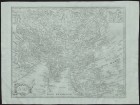
Map of the Far East
Technical and Construction Committee of the Ministry of Internal Affairs. Map of the Far East.
Maps of regions and certain regions of the Far East: the Amur, Yakut and Primorsky regions; Yenisei and Irkutsk provinces, the cities of Balagansk, Verhnelensk, Kansk, Nizhneudinsk and Vladivostok
Technical and Construction Committee of the Ministry of Internal Affairs.
Maps of regions and certain regions of the Far East: the Amur, Yakut and Primorsky regions; Yenisei and Irkutsk provinces, the cities of Balagansk, Verhnelensk, Kansk, Nizhneudinsk and Vladivostok.
Map of the Far East
Borodovsky, L.Karta of the Far East. St. Petersburg: Type. V. Kirschbaum, 1904.
Map of the Far East. Alphabetical index of geographical names placed on the map. 1904
Borodovsky, Leonid Ivanovich (1870-1906). Map of the Far East. Alphabetical index of geographical names placed on the map. 1904 year.
St. Petersburg: Printing house of VD Smirnov, 1913.
Map of Irkutsk province, Tunkinskaya and Torsk hollows, and Ilchinsko Kultukskaya valley // Izvestia of the East Siberian department of the Russian Geographical Society. 1909, Vol. 40 (1910)
Russian Geographical Society. East-Siberian department Izvestiya of the East Siberian Division of the Russian Geographical Society. The map of Irkutsk province, Tunkinskaya and Torsk hollows, and Ilchinsko Kultukskaya valley. Location: Irkutsk, 1870-.
Primorsky Region. Map of the regions that are part of the vice-province of the Far East
Technical and Construction Committee of the Ministry of Internal Affairs.
Primorsky Region. Map of the regions that make up the governorship of the Far East.
Maps for a brief military-geographic and military-strategic review of the Far East
Arseniev, Vladimir Klavdievich (1872-1930). Maps for a brief military-geographic and military-strategic review of the Far East. Film B. m .: Litogr. Priamur. military. Topogr. ord., 1911.
Military topographic maps of the Far East, Manchuria, China and Japan. Editions of 1913 and others
Ryabikov Pavel Fedorovich, general, professor of the General Staff Academy.
Military topographic maps of the Far East, Manchuria, China and Japan. Editions of 1913 and others.
