Internet resources: Google Maps adds “Helicopter view” feature
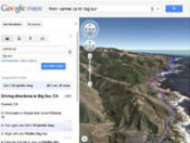
Google Maps has added new “Helicopter view” feature that allows you to preview the recommended route as if you were flying in the helicopter.
To preview the route start by entering your starting point, destination, and mode of transport like any directions. Then, click on the “3D” button. The map will switch to Earth view and automatically start flying you along your recommended route, Google blog reads. In order to use 3D driving directions you’ll need to have Google Earth plug-in installed on your computer.
You can pause the virtual flight at any time. In this case Google Earth standard settings will become accessible. While the flight is paused, you can explore the surrounding area in 3D by clicking and dragging the map. When the feature is on you can’t change these settings.
The new option is available for those regions where Google Maps can draw the route. Developers believe that “Helicopter view” feature will improve travel planning and offer the scenery users will meet on their way. To return back to usual top-down view click “2D” button.