General plans
General plans

St. Petersburg Province. The plan of the terrain, shot before it was conquered by Peter the Great with the indication of Swedish fortifications with a detailed description of the city buildings and avenues. 1698
Russia. Ministry of the Interior. Technical and Construction Committee. St. Petersburg Province. The plan of the terrain, shot before it was conquered by Peter the Great with the indication of Swedish fortifications with a detailed description of the city buildings and avenues. 1698 [1698-1810].
1698
Федеральное казенное учреждение "Российский государственный исторический архив"
The plan of the city of St. Petersburg
Maps, plans and drawings of the St. Petersburg Senate Archive (collection).The plan of the city of St. Petersburg.
1732
RGIA
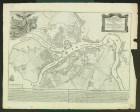
The plan of the Imperial capital of St. Petersburg composed in 1737
The plan of the imperial capital of St. Petersburg composed in 1737.[Saint-Pétersbourg, 1892].
1892
Institute of Research of Eastern and Southeast Europe (Regensburg)

F.B.Rastrelli."Plan of St. Petersburg" (central part).Copy.Appendix: Letter N.G.Reznikova.
F.B.Rastrelli."Plan of St. Petersburg" (central part).Copy.Appendix: Letter N.G.Reznikova. 2004.
1740
Русское географическое общество. Научный архив

The plan of the capital city of St. Petersburg with the image of the most famous avenues
Plan of the capital city of St. Petersburg with the image of the noblest avenues. St.Petersburg: [Printing House of the Academy of Sciences], 1753.
1753
РГБ

The map of the St. Petersburg province of the county of the uyezd is an exciting part and the provinces of the provinces belonging to the province of Shlisselburg, Sophia, Oranieboum and Rozhestva, and it has the center of the city of St. Petersburg and from it stretches in all directions for 40 versts
The map of the St. Petersburg province of the uyezd of the uyezd is an exciting part of the protschi uyezds belonging to the province of Shlisselburg, Sophia, Oranimboum and Rozhestva and it has the center of the city of St. Petersburg and from it stretches in all directions for 40 versts. St. Petersburg: [Provincial Landmark Drawing], 1792.
1792
РГБ

St. Petersburg Province. Plan of St. Petersburg after the flood of 1824 1831
Russia. Ministry of the Interior. Technical and Construction Committee. St. Petersburg Province. The plan of St. Petersburg after the flood of 1824, 1831, 1824-1831.
1824
Федеральное казенное учреждение "Российский государственный исторический архив"
St. Petersburg Province. Map or general topographic survey of the estimates of the space of St. Petersburg. 1835
Russia. Ministry of the Interior. Technical and Construction Committee. St. Petersburg Province. Map or general topographic survey of the estimates of the space of St. Petersburg. 1835 г.1835.
1835
Федеральное казенное учреждение "Российский государственный исторический архив"

St. Petersburg Province. Plan of St. Petersburg. 1840
Russia. Ministry of the Interior. Technical and Construction Committee. St. Petersburg Province. Plan of St. Petersburg. 1840 g.1840.
1840
Федеральное казенное учреждение "Российский государственный исторический архив"

Map of St. Petersburg Uyezd in St. Petersburg Province
Russia. Ministry of the Interior. Technical and Construction Committee. Map of the Petersburg district of St. Petersburg province. 1854.
1854
Федеральное казенное учреждение "Российский государственный исторический архив"