Cartographic materials
Cartographic materials

A photocopy of the card path of Peter I of Nyuhotskoy parish in Povenets in 1702 (Petrozavodsk County, Olonets province)
Technical and Construction Committee of the Ministry of Internal Affairs.A photocopy of the card path of Peter I of Nyuhotskoy parish in Povenets in 1702 (Petrozavodsk County, Olonets province).
б/д
Федеральное казенное учреждение "Российский государственный исторический архив"

Ban
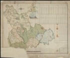
General map of the Arkhangelsk and Olonets governorship
Доступно только в Электронных читальных залах

Map of the St. Petersburg province.and Olonets region, comp.Yarkov
Map of the St. Petersburg province.and Olonets region, comp.Yarkov.
Доступно только в Электронных читальных залах

Geometric map of the Olonets lips.
Geometric map of the Olonets lips.
Доступно только в Электронных читальных залах

"The Landcarta of the Principality of Finland with the counties of Vyborg, Kexholm and Shlisselburg, with a part of the Novgorod, Olonets, Arkhangelogorod and Kola counties, also part of the coast of Stockholm and Ingermolandia."
"The Landcarta of the Principality of Finland with the counties of Vyborg, Kexholm and Shlisselburg, with a part of the Novgorod, Olonets, Arkhangelogorod and Kola counties, also part of the coast of Stockholm and Ingermolandia."
Доступно только в Электронных читальных залах

Drawing of Lake Rostov.- -.-First sexes.XVIII century.;Kart.Op.107;36x48;Additional Agreement No. 1 of May 21, 2021 to the contract.No. 90-19 dated August 27, 2019 (Ban)..Electronic copy source: ban
Map of Ladoga lake.and channel.
Доступно только в Электронных читальных залах

Ladoga lake.An excerpt of the map of the northern part of Lake Ladoga (with the island of Valaam) and part of Finland.
Ladoga lake.An excerpt of the map of the northern part of Lake Ladoga (with the island of Valaam) and part of Finland.
Доступно только в Электронных читальных залах

The map showing marble mountains in Olonets governorship.- [after 1784]
The map showing marble mountains in Olonets governorship.- [after 1784].
Доступно только в Электронных читальных залах

Ladoga Lake and Gulf of Finland with adjacent places = Lacus Ladoga et sinus finnicus cum interiacentibus et adiacentibus regionibus / J.Grimel del.-[1741-1742]
Ladoga Lake and Gulf of Finland with adjacent places = Lacus Ladoga et sinus finnicus cum interiacentibus et adiacentibus regionibus / J.Grimel del.-[1741-1742].
Доступно только в Электронных читальных залах
Pages
- Plans

Olonets province.Plan of Petrozavodsk
Technical and Construction Committee of the Ministry of Internal Affairs.Olonets province.Plan of the city of Petrozavodsk.
Olonets province.Plan Olonets
Technical and Construction Committee of the Ministry of Internal Affairs.Olonets province.Plan Olonets.
Plan of Olonets. Script. July 18, 1837
Plan of Olonets. Script. July 18, 1837, 1837.
Olonetskaya province.Copy of the Plan of the city of Olonets.1910
Olonetskaya province.Copy of the Plan of the city of Olonets.19101910.
Olonetskaya province.Plan and facades of the longitudinal and side of the alleged living yard in Mountains.1819. Copy with copy.
Olonetskaya province.Plan and facades of the longitudinal and side of the alleged living yard in Mountains.1819. Copy from copy.1819.
The plan of the city of Lodeynoye Field of the Olonets province
Maps, plans and drawings of the St. Petersburg Senate Archive (collection).The plan of the city of the Lodeynoye Field of the Olonets province.
Olonets province.Plan of Povenets
Technical and Construction Committee of the Ministry of Internal Affairs.Olonets province.Plan of Povenets.
Olonets province.Plan Pudozh
Technical and Construction Committee of the Ministry of Internal Affairs.Olonets province.Plan Pudozh.