Far East until 1917
Far East until 1917
The case of the device and transformations in the Kamchatka, Okhotsk and Yakut regions. N. 1810; V.u. 9 / IV-1812.
The case of the device and transformations in the Kamchatka, Okhotsk and Yakut regions. N. 1810; V.u. 9 / IV-1812, 1810.
РГИА

The case under the decree of the Government Senate on the relations of the provincial governments to the Yakut and Primorye: the Kamchatka and Okhotsk departments
Collection: The case according to the decree of the Government Senate on the relations of the provincial governments to the Yakut and Primorye: Kamchatka and Okhotsk departments
1838
РГИА

On the abandonment without consequences of the assumption of the transfer of Mr. Gizhigi to Kolosov Uval. December 8 - December 22, 1854
On the abandonment without consequences of the assumption of the transfer of Mr. Gizhigi to Kolosov Uval. December 8 - December 22, 1854, 1854.
РГИА

Ryabikov PF "Note on the present situation in the Far East"
Ryabikov Pavel Fedorovich, general, professor of the General Staff Academy.
Ryabikov PF "A note on the present situation in the Far East".
Ryabikov PF "A note on the present situation in the Far East".
1875
ГА РФ
On the reduction of public spending on the events in the Far East
State Chancellery of the State Council.
About reduction of the state expenses on the occasion of events in the Far East.
About reduction of the state expenses on the occasion of events in the Far East.
1900
Федеральное казенное учреждение "Российский государственный исторический архив"

Pokotilov's report on the Far East
Witte, gr. Sergei Yulievich (1849-1915), Minister of Railways, Minister of Finance, Chairman of the Committee of Ministers, Chairman of the Council of Ministers.
Reporting Pokotilov in the Far East.
Reporting Pokotilov in the Far East.
1900
Федеральное казенное учреждение "Российский государственный исторический архив" (РГИА)

Collection of the newspaper "Amur Region"
"Amur Region", newspaper (Blagoveshchensk). Collection of the newspaper "Amur Region." Blagoveshchensk: Printing house GI Klitchoglu and Co., 1900.
1900
Амурская ОНБ

Correspondence between the Chairman of the Council of Ministers and the Minister of Foreign Affairs, the Russian representatives in China and Japan, the Amur Governor-General, the Chief of the General Staff and other officials on the management of the Amur region and Russia's relations with China and Japan: the revolutionary uprising of soldiers of the Chinese garrison in Al -Tour of Anhui province (China); on the armament of Japan and the preparation of its military bases in South Manchuria and North Korea; on the draft budget of Japan for 1908-1909; on the establishment of the Japanese consulate in the city of Petropavlovsk-on-Kamchatka and the striving of the Japanese to extend their influence to the Kamchatka population; about the desire of the Japanese to include in the district of the Japanese consulate in the mountains. Nikolayevsk-on-Amur in the northern part of Primorsky Region; on the activities of the Japanese society "Toa-Dubunkai" (Society of East Asian Unified Writing); on the awarding of officials of the Ministry of Foreign Affairs of Japan for participating in the conclusion of treaties and agreements with Russia and France; about new flights of the Japanese steamship service through the port of Dalny; on the formation in Japan of the "Union of Fishing Industry of the Primorsky Region and the need to limit the predatory fishing of the Japanese in Russian waters, the production of a loan by China in the United States, the alleged state reforms in China, the activities of the Chinese government to combat opecurium in the Ili edge, the Chinese colonization of the right bank the Amur River, the strengthening of the defense of the city of Vladivostok, the navigation of Chinese and Russian ships along the Amur River, the restriction of the employment of Chinese, Japanese and Korean workers in the Amur region, and the reorganization of its management, the development of mining industry in the Primorsky region, the construction of a cableway from the Sucean Coal Mines to the Nakhodka Bay for defense purposes, at the request of Captain Tygerstedt to grant him a concession for the right to exploit forest resources in the area the Gulf of DeKastri and the construction of a railway to it, the rental of a private individual to the island of Karagi off the eastern shores of Kamchatka, with the annex of the island plan; on the leasing of land and fishing areas in the Priamursky Governor-General; The list of cases on the management of the Far East, considered in the Council of Ministers from January 12, 1908 to January 19, 1909. September 5, 1907 - July 22, 1909
Russia. Council of Ministers. Correspondence between the Chairman of the Council of Ministers and the Minister of Foreign Affairs, the Russian representatives in China and Japan, the Amur Governor-General, the Chief of the General Staff and other officials on the management of the Amur region and Russia's relations with China and Japan: the revolutionary uprising of soldiers of the Chinese garrison in Al -Tour of Anhui province (China); on the armament of Japan and the preparation of its military bases in South Manchuria and North Korea; on the draft budget of Japan for 1908-1909; on...
1907
Федеральное казенное учреждение "Российский государственный исторический архив"

Documentary materials submitted to the Council of Ministers on the management of the Far East
Council of Ministers (1905-1917).
Documentary materials submitted to the Council of Ministers on the management of the Far East.
Documentary materials submitted to the Council of Ministers on the management of the Far East.
1901
Федеральное казенное учреждение "Российский Государственный Исторический Архив"

The Case of the Council of Ministers on the Management of the Far East
Council of Ministers (1905-1917). The Case of the Council of Ministers on the Management of the Far East.
1908
Федеральное казенное учреждение "Российский Государственный Исторический Архив"
Pages
- Cartographic materials
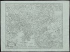
Asia.- [17 - -]
Asia.- [17 - -].
The map representing inventions by Russian sailors in the northern part of America with near the lying places of the studied / composed at the imper.Academy of Sciences with the titular adviser Ivan Trusk.- [17 - -]
The map representing inventions by Russian sailors in the northern part of America with near the lying places of the studied / composed at the imper.Academy of Sciences with the titular adviser Ivan Trusk.- [17 - -].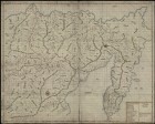
Map of the Yakut region on the lower reaches of the river.Lena from Vitim to the mouth and Kamchatka, comp.P. Skobeltsin, I. Svistunov, D. Baskakov, V. Shetilov
Map of the Yakut region on the lower reaches of the river.Lena from Vitim to the mouth and Kamchatka, comp.P. Skobeltsin, I. Svistunov, D. Baskakov, V. Shetilov.
Landantcart of Eastern Siberia from the prison of Vitim to Kamchatka, comp.P. Skobeltsin, I. Svistunov, D. Baskakov, V. Shetilov
Landantcart of Eastern Siberia from the prison of Vitim to Kamchatka, comp.P. Skobeltsin, I. Svistunov, D. Baskakov, V. Shetilov.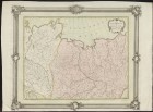
Part of the Mangazesiskago and Yakutskogo county with the mouths of the Yenisei and Lena / Op.I. Truskot;Cutting P. Kholodov;Grid.I. Kuvakin
Part of the Mangazesiskago and Yakutskogo county with the mouths of the Yenisei and Lena / Op.I. Truskot;Cutting P. Kholodov;Grid.I. Kuvakin.1770.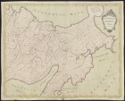
The eastern part of the Yakutsk district / Op.I. Truskot;I. Kuvakin cut out
The eastern part of the Yakutsk district / Op.I. Truskot;I. Kuvakin cut out.1772.
The sea of Baikal with part of the rivers of Lena, Arguni, Selenges and Angara with near the lying counties
The sea of Baikal with part of the rivers of Lena, Arguni, Selenges and Angara with near the lying counties.[St. Petersburg: Geographical Department of the Imperial Academy of Sciences], 1772.
The first manuscript map of Kamchatka, the Aleutian Islands and Alaska, compiled by Major TI Shmalev
The first manuscript map of Kamchatka, the Aleutian Islands and Alaska, compiled by Major TI Shmalev. 1775.
Map of the Chukotsky Nose / communicated from Colonel Pretnener;OSR [RI].L. SERGEEV
Map of the Chukotsky Nose / communicated from Colonel Pretnener;OSR [RI].L. SERGEEV.1780.
A map of the course of the Irtysh River from the Omsk Fortress to Tobolsk / Soicated at the Emperor.Academy of Sciences I.Sleniev;neckline.Pupil L. Sergeev
A map of the course of the Irtysh River from the Omsk Fortress to Tobolsk / Soicated at the Emperor.Academy of Sciences I.Sleniev;neckline.Pupil L. Sergeev.1780.
A map of new discoveries in the Eastern Ocean / Zero.E. Khudyakov
A map of new discoveries in the Eastern Ocean / Zero.E. Khudyakov.1781.
Map of Lake Baikal, Sea, Lake, or Angarsky failure, in the Irkutsk province of consisting, with all its circles, which is ended with mathematical dimension and is brought into perfect fame in 1806
The map of Lake Baikal, the Sea, Lake, or Angara failure, in the Irkutsk province of consisting, with all its circles, which is ended with a mathematical dimension and is brought into perfect fame in 1806.[B.M .: b.and., after 1806].
The map of part of North-East Asia and North-West America / compiled according to the latest observations by academician V. Vishnevsky
The map of part of North-East Asia and North-West America / compiled according to the latest observations by academician V. Vishnevsky.1818.
Map of Siberia, compiled from the following works: Travels of Captain Sarychev from 1785 to 1793 in northeastern Siberia, from Letters on Eastern Siberia Martos, published in 1827; from Travel in 1829 to Siberia Humbolt, published in 1837; Comments on Sib
Map of Siberia, compiled from the following works: Travels of Captain Sarychev from 1785 to 1793 in northeastern Siberia, from Letters on Eastern Siberia Martos, published in 1827; from Travel in 1829 to Siberia Humbolt, published in 1837; Comments on Siberia by Senator Karnilov, published in 1828; Descriptions of the Yenisei Provincial Senator Stepanova, published in 1835; Travel to Yakutsk in 1830 by Shchukin, published in 1833; Traveling on the northern shore of Siberia from 1820 to 1824 Lieutenant Wrangel, published in 1841; from a fragment about Siberia Gedenstrom,...
The general map of the golden crafts of Eastern Siberia with the addition of the most important gold districts or systems of the Yenisei province / comp.Helmersen
The general map of the golden crafts of Eastern Siberia with the addition of the most important gold districts or systems of the Yenisei province / comp.Helmersen.1845.Доступно только в Электронных читальных залах
A map of the mouth of the Amur River (pencil) and a portrait of MN Muraviev (lithography)
MURAVYEV MIKHAIL NIKOLAEVICH, GRAPH, GENERAL OF INFANTERIUM, DIRECTOR OF DEPARTMENT OF DIFFERENT FELLOWS AND CHARGES, MEMBER OF STATE COUNCIL, MINISTER OF STATE PROPERTY (1857-1862), MILITARY GENERAL-GOVERNOR OF VILENCIA GOVERNIA (1863).
The map of the mouth of the Amur River (pencil) and a portrait of MN Muraviev (lithography).
The Atlas of the mouth of the Amur River, compiled from the filming of 1855-1863, at the Hydrographic Department
The Atlas of the mouth of the Amur River, compiled from the filming of 1855-1863, at the Hydrographic Department. [St. Petersburg], 1864.
The Baikal Lake Map. Reconnaissance of Lake Baikal in 1896
Map of Lake Baikal.

Map of Lake Baikal // News of the Russian Geographical Society. T. 33 1897, vol. 2 (1897)
Russian Geographical Society News of the Russian Geographical Society. Map of Lake Baikal.
St. Petersburg: Science, St. Petersburg Branch, 1865-.
Geological map of Lake Baikal // Izvestiya of the East Siberian Division of the Russian Geographical Society. 1881 T. 12, No. 2/3 (1881)
Russian Geographical Society. East-Siberian department. Izvestiya of the East Siberian Division of the Russian Geographical Society. Irkutsk, 1870-.
Geological map of Lake Baikal.
Geological map of the area adjacent to the Siberian postal route from Lake Baikal to the river. Ob, and also to the roads in Minusinsk and the Padunsky rapids on the Angara //. Geological study of the Siberian postal tract from Lake Baikal to the eastern
Geological map of the area adjacent to the Siberian postal route from Lake Baikal to the river. Ob, and also to the roads in the city of Minusinsk and the Padunsky threshold on the Angara.

Geological map of the Irkutsk coal-bearing basin // Izvestiya of the East Siberian Division of the Russian Geographical Society. 1902 T. 33, The Last (1903)
Russian Geographical Society. East-Siberian department Izvestiya of the East Siberian Division of the Russian Geographical Society. Geological map of the Irkutsk coal basin. Location: Irkutsk, 1870-.
Map of the Far East
Technical and Construction Committee of the Ministry of Internal Affairs. Map of the Far East.
Maps of regions and certain regions of the Far East: the Amur, Yakut and Primorsky regions; Yenisei and Irkutsk provinces, the cities of Balagansk, Verhnelensk, Kansk, Nizhneudinsk and Vladivostok
Technical and Construction Committee of the Ministry of Internal Affairs.
Maps of regions and certain regions of the Far East: the Amur, Yakut and Primorsky regions; Yenisei and Irkutsk provinces, the cities of Balagansk, Verhnelensk, Kansk, Nizhneudinsk and Vladivostok.
Map of the Far East
Borodovsky, L.Karta of the Far East. St. Petersburg: Type. V. Kirschbaum, 1904.
Map of the Far East. Alphabetical index of geographical names placed on the map. 1904
Borodovsky, Leonid Ivanovich (1870-1906). Map of the Far East. Alphabetical index of geographical names placed on the map. 1904 year.
St. Petersburg: Printing house of VD Smirnov, 1913.
Map of Irkutsk province, Tunkinskaya and Torsk hollows, and Ilchinsko Kultukskaya valley // Izvestia of the East Siberian department of the Russian Geographical Society. 1909, Vol. 40 (1910)
Russian Geographical Society. East-Siberian department Izvestiya of the East Siberian Division of the Russian Geographical Society. The map of Irkutsk province, Tunkinskaya and Torsk hollows, and Ilchinsko Kultukskaya valley. Location: Irkutsk, 1870-.
Primorsky Region. Map of the regions that are part of the vice-province of the Far East
Technical and Construction Committee of the Ministry of Internal Affairs.
Primorsky Region. Map of the regions that make up the governorship of the Far East.
Maps for a brief military-geographic and military-strategic review of the Far East
Arseniev, Vladimir Klavdievich (1872-1930). Maps for a brief military-geographic and military-strategic review of the Far East. Film B. m .: Litogr. Priamur. military. Topogr. ord., 1911.
Military topographic maps of the Far East, Manchuria, China and Japan. Editions of 1913 and others
Ryabikov Pavel Fedorovich, general, professor of the General Staff Academy.
Military topographic maps of the Far East, Manchuria, China and Japan. Editions of 1913 and others.

On the management of Amur Region (scans 15, 16, 20-22, 28-31, 37, 38, 45-61, 71-92, 98-100, 103-119, 121-130)